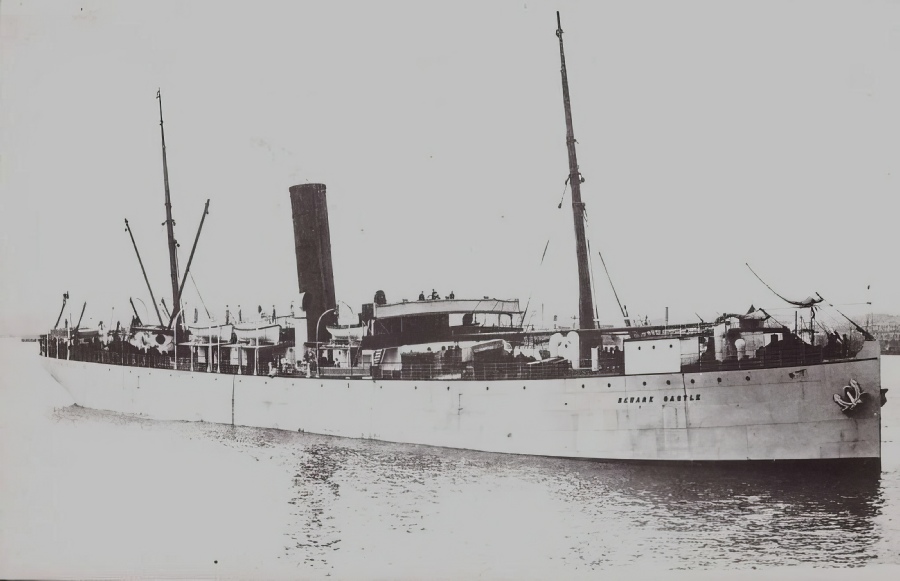
NEWARK CASTLE was built in 1902 by Barclay, Curle & Co. at Glasgow with a tonnage of 6224 grt, a length of 414 ft 8 in, a beam of 51 ft 2 in and a service speed of 14 knots.
She was the last of the class and the names were never repeated.
At noon on 12th March 1908 she sailed from Durban bound for Mauritius via Delagoa Bay with a crew of 69 and 48 passengers mainly soldiers of the Mauritius garrison.
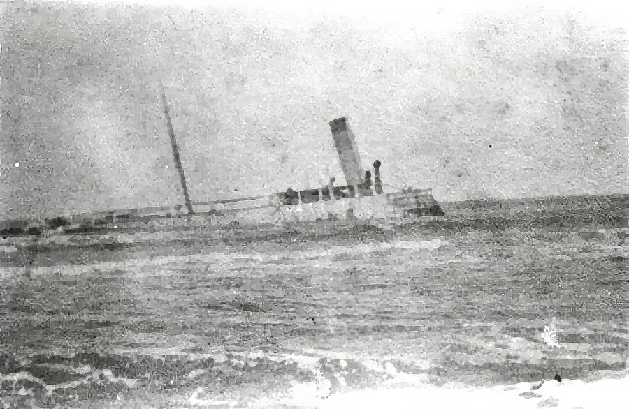
Six hours later she ran aground on a shoal four miles out from Richards Bay, Umhlatuzi River near to Port Durnford on the Zululand coast.
|
Master |
From |
To |
|
F W Bate |
4/1902 |
3/1903 |
|
B A Bryan |
3/1903 |
8/1903 |
|
F W Bate |
9/1903 |
6/1905 |
|
W W Verrall |
7/1905 |
5/1907 |
|
N R Neilson |
6/1907 |
3/1908 Wrecked |
The sea was calm and all the boats were lowered while the captain and some of the crew remained on board. Later in the day the wind and seas increased endangering all. The Durban trawler, Elelyn, arrived early next morning and rescued the occupants of all but one lifeboat.
The remaining boat attempted to reach the shore but was swamped by the rising sea and three men were drowned.
The rough seas floated the Newark Castle off but the wind then blew her back onto a sandbank seven miles way where she became a total loss.
REPORT of a Court of Inquiry held at Durban, Natal, on the 26th, 27th and 31st days of March, and the 2nd, 3rd, 9th, 10th and 14th days of April, 1908, to investigate the circumstances attending the loss of the s.s. "Newark Castle" off Port Durnford, Coast of Zululand, on the 12th March, 1908.
14th April, 1908.
This matter comes before the Court on the following documents filed by the Acting Attorney General in terms of Law No. 10 of 1883 (Natal).
"In the matter of the British ship ' Newark Castle,' steamship, of 4,047 tons net, 6,224 tons gross, No. 115,806, registered at London, whereof Nathaniel Ross Neilson is master.
"In the Court constituted under Law No. 10, 1883, to enquire into the circumstances of the wreck of the said ship on the 12th March, 1908.
"In terms of sub-section (a) of Section 3 of Law No. 10, 1883, the Attorney General charges Nathaniel Ross Neilson, master, and George Joseph Whitfield, chief officer of the ship 'Newark Castle,' or one or other of them, with misconduct.
"In that upon the 12th day of March, 1908, the said ship 'Newark Castle' was upon a voyage from Port Natal to the port of Delagoa Bay and was off Port Durnford, on the Coast of Zululand, Colony of Natal;
"That by the neglect of the said Nathaniel Ross Neilson and George Joseph Whitfield, or one or other of them, the ship was navigated so close to the shore as to be in danger of being wrecked.
"That in consequence thereof the ship 'Newark Castle' at about 5.55 p.m. struck twice upon something supposed to be a reef or other obstruction, and sprang a leak.
"That the said Nathaniel Ross Neilson ordered the boats to be manned and left the ship with the crew too soon, in consequence whereof the said ship stranded subsequently becoming a total loss."
At 10.45 a.m. on the 12th March, 1908, the "Newark Castle" took her departure from outside the breakwater, the Bluff Lighthouse bearing S. 40 W.
The course set was N. 68 E. (by compass-N. 40 E. true). This was allowing an error of 28 degrees west on that course.
The evidence of Captain W. H. Smyth, the master of the "Umtata," who has perhaps had more experience than any other shipmaster trading to this part of the coast between this port (Durban) and Delagoa Bay, says that the course set was a correct one.
At noon the vessel had travelled 13 miles according to the patent log.
Up to this time the third officer was on the bridge.
At noon the second officer went on to the bridge, relieving the third officer.
Between 3 and 4 p.m. the vessel was off the Tugela River, but no bearings were taken to ascertain the distance of the vessel from the shore. This ought to have been done.
At 4 p.m. the second officer left the bridge, handing to the master the following memorandum:
 The second officer at 4 p.m. was relieved by the chief officer, who is the holder of an extra-master's certificate.
The weather at this time was as follows:
Wind: E.S.E., light.
Sea: Moderate.
Atmosphere: Clear, no haze over the land.
The master was on the lower bridge watching the coast from time to time and looking out for Point Durnford, with which he states he had become entirely familiar, the design being on approaching that landmark to haul the ship out so as to pass Cape Saint Lucia at a distance of five miles.
The chief officer states that he was carefully watching the coast all the way up with a view of taking a bearing, but without success; that he endeavoured to obtain a four-point bearing of Point Durnford, but that the sun was over the land before Point Durnford came abeam so that it was a matter of difficulty to obtain a position by bearings.
The master states that he judged the vessel to be at least 3 to 3 3/4 miles from the land when off Point Durnford and was in no alarm whatever at her being in any position of danger.
At 5.30 p.m. the vessel's course was changed six degrees to the eastward, making the true course N. 46 E. in order to steer a course parallel to the land up to a position off Cape St. Lucia.
The master admitted that the original course set from Durban, even with the alteration as above, would have placed the "Newark Castle" within 3/4 of a mile off Point Durnford, but alleges that the current had set the vessel when she was abreast of Point Durnford. at least 2 1/4 miles outside the true course, thus making the vessel from 3 to 3 1/4 miles off the land.
The chief officer, not being able to get an exact bearing off Point Durnford, swore that he selected a patch of bush to the northward of Point Durnford, and took a five point bearing of this patch (a patch was pointed out by the chief officer as being to the best of his recollection the patch in question, and ascertained to be as nearly as possible two miles to the northward of Point Durnford).
When this patch was abeam the distance of the vessel from the shore was ascertained to be 2.88 miles.
The chief officer swore definitely to such a bearing having been taken, and he was confirmed on oath by the 4th officer, who deposed to having assisted him in taking the bearing.
This five-point bearing, according to the evidence of the officers, was taken at 5.38 p.m., the patch of bush referred to being abeam at 5.49 p.m. No record of this bearing was made at the time in any Rough Deck Log Book, the intention being said to be to record it in the usual way a few minutes later.
The master having ascertained that the vessel had been hauled out six degrees at 5.30 p.m., was quite content that the vessel was in a position of safety, though he does not seem to have enquired whether any bearings had been taken to ascertain the exact distance of the vessel from the shore, nor to have given any instructions to have any such bearings taken.
He explained that his knowledge of the coast was so intimate, and the atmosphere so clear, that he, keeping a constant look-out, was quite able to judge that the vessel was at a perfectly safe distance from the land.
The evidence of Major-General Dalton, who was a passenger, shows that the master had shortly before (about 20 minutes before), taken him to the Chart Room and explained to him the position of the vessel on the chart.
The vessel ran for 11 minutes after the first bearing had been taken at an average speed of 10 1/2 knots, which would place her between two and three miles to the northward of Point Durnford.
She then struck some obstruction twice, the interval of time between the shocks being a matter of a few seconds.
It is to be regretted that no attempt was then made to take soundings to determine the depth of the water, and in the opinion of the Court, and of the assessors, this was a step which should have been taken.
Soundings of the wells were at once taken, when it was reported to the master that the whole ship was dry, except the engine-room compartment.
From the evidence given by the engineers, water came into the engine compartment very fast immediately after striking, the second engineer being of opinion that the ship had struck where the tank top joins the ship's sides, and that the plating had been carried away just where the bunker bulkhead joins the tank top.
No examination seems to have been made at this time of the patent log to ascertain what distance the vessel had travelled since noon.
The 4th officer states that about eight or nine minutes after the striking, the master ordered him to take a bearing of a prominent. wooded hill which the 4th officer was not familar with, but which the master subsequently identified as the centre hill of the three hills which comprise the height which is known as "Point Durnford."
The 4th officer states that this point bore N. 51. W. (by compass) from the ship.
The report made to the master showed that the reserve buoyancy of the vessel would, under normal conditions, have been sufficient to keep the vessel afloat, but as she began to list heavily an apprehension was felt that the vessel was in immediate danger of capsizing, and all hands were ordered to take to the boats.
The testimony of Major-General Dalton shows that the master and officers were perfectly cool and collected, and that the whole work of getting the passengers and crew into the boats was carried out in a manner which reflected credit on the discipline maintained on the vessel.
The vessel was finally abandoned about 6.30 p.m.
After the striking the ship's helm was at once put "hard aport" until the ship's head was approximately S.E., and, as far as can be ascertained, she had run from 1 to 1 1/2 miles on this course when the engines stopped.
Assuming the chief officer's estimate to have been correct, and that the vessel at the time of striking was 2.88 miles from the land, she would at the time of her abandonment have been from 4 to 4 1/2 miles from land, in a locality where the chart shows a depth of approximately 12 fathoms.
The master states that, being apprehensive that the vessel was about to capsize, he instructed the boats to keep a safe distance from the vessel to avoid the vortex, his intention being to stand by the vessel, so that if she continued to float, he could board her again and take such steps as might be necessary to ensure her safety.
At about 7 p.m. the wind changed to S.W. and freshened.
The boat of which the master was in charge was driven some six miles to the N.E., and in spite of every effort being made he was not able to make the ship again during the night.
The vessel, owing to the wind and current, drifted during the night in a northerly direction towards the shore.
At 10 p.m. the 3rd officer was able to board the vessel from his boat, which was in a more favourable position to effect such return, than that of the master.
He fired off signals of distress and left the vessel after being on board about 20 minutes.
At 2 a.m., finding that the vessel did not capsize, he returned, took soundings, finding 24 feet of water, and let go the anchors.
The vessel was then afloat, but on the anchors being let go she swung round to her anchors and took the ground heavily aft.
One witness states that on the occasion of the return to the vessel he examined the patent log, and the record was 65 miles (that is from noon).
The next morning the master and his boat's crew were rescued by a steam trawler, the crew being thoroughly exhausted, and he then again boarded the vessel.
Eventually all the occupants of the boats, except the boat in charge of the 4th officer, were rescued and brought to Durban.
The boat in charge of the 4th officer endeavoured to effect a landing on the coast to the northward of Point Durnford.
The boat was capsized in the surf with the lamentable result that Mr. Boys, (a passenger), Steward Horne, and the ship's boy, Matsell, were drowned.
The vessel became a total wreck, having been driven ashore at or near the mouth of the Umhlatuzi River.
The explanation given by the master and the ship's officers of the extreme list taken by the vessel after striking, is that the natural tendency of the vessel to lift on account of the inrush of water was increased by reason of the vessel being "tender" owing to the distribution of the cargo in the lower holds and 'tween decks.
The vessel appears, however, to hare been properly loaded to meet all the ordinary contingencies of a. voyage.
There is no doubt that the vessel, after striking, owing to the inrush of water on the port side and other causes, did list to such an extent that the: master bad reason to apprehend an immediate danger of the vessel capsizing, and he was bound, under such circumstances, to regard the safety of his passengers and crew as of paramount importance.
Having in view the fact that no record has been preserved of the bearings taken by the chief officer, that no soundings had been taken immediately after striking, and the fact that the chief officer stated his ability to point out the patch of bush in respect of which he had taken a bearing at 5.38 p.m., and having further in view the great importance of leaving nothing undone to endeavour to solve the question as to the exact point where the vessel had struck, the Court and Assessors concurred in asking the government to put the steam tug "Harry Escombe" at the disposal of the Court to enable an inspection of the locality to be made.
This request was acceded to, and on the 8th April instant, the president and assessors, accompanied by Captain Rainnie (port captain), the master, chief officer, and fourth officer of the "Newark Castle" left the breakwater at 7.20 a.m.
The wind was moderate, easterly, and the tide was about one hour from high water.
A course of N.40.E. true, being identical with the course set by the "Newark Castle," was laid down, and the vessel was most carefully steered under the personal direction of the port captain.
At the time of departure of the "Newark Castle" from the breakwater there was high water at Durban at noon (approximately).
The assessors have worked out, and the Court is satisfied that the conditions of. tide which were experienced by the "Newark Castle" and the "Harry Escombe" were as nearly as possible identical.
The assessors also went carefully into the rise of the tide at the time when soundings were taken from the "Harry Escombe," and the Court is satisfied that the vertical rise of the tide did not exceed half a fathom above the depths given in the admiralty chart.
In both cases the vessels had the effect of the ebb tide tending to set them out to sea.
When the s.s. "Harry Escombe" had reached the neighbourhood of the mouth of the Tugela River, four-point bearings were taken at the mouth of such river immediately before noon and observations were obtained of the sun to ascertain the latitude and longitude at noon, and the ship's position definitely ascertained.
The distance of the vessel from the Tugela and the various observations taken were definitely verified and agreed to by the master and chief officer of the "Newark Castle."
The vessel was then found to be 9 1/4 miles from the Tugela mouth, and had thus, in the distance of 42 1/2 miles run from Durban, been set out two miles out to sea beyond the exact course laid down and steered.
The compass of the "Harry Escombe" (Lord Kelvin's) had been carefully tested by the Port Captain the day before, the vessel having been duly swung at sea, the total error being eight degrees West on this course.
At 2.58 p.m. Point Durnford was abeam, distant four miles.
The distance was ascertained by four-point bearings and proved by vertical angle.
It was then found that the "Harry Escombe" had been set out seaward (eastward) 3 3/4 miles outside the course laid down and steered, most conclusively proving that some influence had been steadily at work placing the vessel out to sea, tending to corroborate the statement of the master of the "Newark Castle" that his vessel, being approximately under the same conditions, had been, in like manner, set out to sea from the line of the course laid down for her and steered.
The chief officer was asked to indicate the patch of bush in respect of which he had taken his five-point bearing.
He indicated as being absolutely, to the best of his recollection, the patch in question, a patch of bush with two streaks of white sand on either side.
This patch formed, on closer approach, a mark which stood out clearly from the rest of its surroundings.
The "Harry Escombe" was then steered straight for the land until she had reached a position of three miles abreast of Point Durnford, this being as nearly as possible the "Newark's" position when passing the point.
The vessel was put on a N.46.E. true course, parallel with the land, until the patch indicated as above was abeam.
From this the vessel stood on for nearly a mile, until the master and chief officer agreed that she was as nearly as possible in the exact position she (the "Newark Castle") was in when she struck.
The "Harry Escombe" was then stopped and the deep sea lead cast.
The result was that a depth of 10 1/2 fathoms of water was found.
From this the ship's head was altered to N.61.W. true, which was directly towards the land, the vessel's speed being "slow."
Frequent soundings were taken, with the result that in no case was less than six fathoms found.
When the vessel was 1 1/2 miles from the shore her head was altered to West true.
The position and course were verified.
The course was continued taking the vessel back to Point Durnford, steering diagonally across what is indicated on the chart as a shoal, and this was continued until the vessel had approached within three-quarters of a mile from the land immediately off Point Durnford.
This position was verified by vertical angle.
The depth of water found at this position was six fathoms.
The Admiralty chart shows four fathoms only.
The coast line and objects on shore at this distance were so clearly defined that no navigator of even average experience of the locality could possibly so have misjudged his distance as to imagine his vessel to be from three to four miles off the shore while in this position.
According to the chart, the "Newark Castle" could not, as regards any known danger or obstacle, be liable to strike anything at any point outside the four-fathom line on the course which she was steering N.46.E. true.
Finding.
(1) That upon the evidence brought before the Court by the Attorney General, and that called by the defence, and the Court, and having in view the information gained by the examination of the locality of Point Durnford made by the Court and Assessors on the occasion of their personal visit on the 8th April, 1908, the Court finds that the "Newark Castle" struck upon some obstruction to navigation not shown upon the chart, or previously known to navigators, and at a point between 2 1/2 miles to 3 miles from the land to the northward of Point Durnford and outside the eight fathom line as indicated on the chart.
(2) That the vessel at the time she was abandoned had developed such a list, and was in such a position, that any prudent master of a vessel was entitled to regard the capsizing of the vessel as an imminent danger and to abandon the vessel for the sake of saving the lives of the passengers and crew.
(3) That the efforts of the master to remain near the vessel were prevented by the south-west wind blowing and the currents running up the coast.
(4) That the loss of the vessel has not been proved to be due to any misconduct or negligence of the master or chief officer, and the Court orders their certificates to be returned to them.
14th April, 1908.
PERCY BINNS,
President.
W. BROWN DICKIE,
J. E. GRINDROD,
Assessors.
A true copy.
PERCY BINNS,
President.
NOTE. ”Greatest draught of "Newark Castle" on leaving Natal” 21 feet 5 inches.
(Issued in London by the Board of Trade on the 5th day of June, 1908.)
Newark Castle Aground
BOT Wreck Report for Newark Castle - 1908
Vessel |
Built |
Tonnage |
Official No |
Ship Builder |
Engine Builder |
Engine Type |
HP |
Screws |
Speed |
|
Newark Castle |
1902 |
6224 |
115806 |
Barclay Curle Glasgow |
2 x Triple Expansion Steam |
3400 IHP |
2 |
14 |
|
Career Summary
Newark Castle
THVG

General Arrangement of Beams & Bulkheads


